Drones & Travel
The Best Drone Apps of 2025: Flight Planning, Mapping, DJI, and More
Drones are easier to operate than ever, and a strong app ecosystem makes the difference between a good flight and a great one. Whether you need hyperlocal we...
Drones are easier to operate than ever, and a strong app ecosystem makes the difference between a good flight and a great one. Whether you need hyperlocal weather data, airspace clearance, automated mapping runs, or sun-path predictions for golden-hour footage, the right app saves time, improves safety, and elevates the final result.
Below is a curated rundown of the best drone apps across flight planning, mapping, DJI integration, and general photography utility.

Best Flight Planning and Weather Apps
UAV Forecast
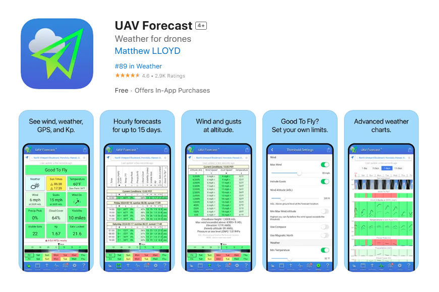
UAV Forecast is the go-to pre-flight weather tool for serious drone operators. It delivers hyperlocal wind speeds, gusts, cloud cover, visibility, and GPS satellite data — all color-coded for quick scanning. You can set custom flight thresholds so the app flags conditions outside your comfort zone. A free tier covers essentials, with subscription options unlocking advanced charts.
If you want something simpler, AURA and Windy are solid alternatives with clean interfaces.
Autopylot
FAA-approved and built for professional pilots, Autopylot integrates airspace data, Temporary Flight Restrictions, LAANC authorization, and comprehensive checklists into a single workflow. It's ideal for operators flying larger drones in controlled airspace who need verifiable compliance and thorough mission planning. The weather tools are strong, though full access requires a subscription.
OpenSky
Free, clean, and map-driven. OpenSky overlays airspace rules, hazard zones, and sensitive locations onto Google Maps and lets U.S. and Australian pilots request LAANC authorization in real time. It's less feature-rich for complex commercial work, but as a free tool it covers what most recreational and semi-professional pilots actually need.
AirData UAV
AirData automatically syncs your flight logs and translates them into readable dashboards covering battery health, GPS signal strength, flight paths, and potential maintenance issues. It's the kind of tool that catches problems before they become emergencies — worth its weight for anyone flying regularly.
Windy
Windy's strength is water data. If you're filming surf, sailing, or coastal landscapes, its wave and tide forecasts — drawn from global ECMWF and GFS models — are invaluable. The interactive map is intuitive, though real-time radar data can be somewhat generalized.
Sun Surveyor
This isn't a drone-specific app, but it's essential for anyone who flies for imagery. Sun Surveyor plots sun and moon paths, golden and blue hour, and Milky Way azimuth and altitude — all with an AR overlay so you can see exactly where the light will fall. For drone photographers, knowing light direction before takeoff means dramatically better footage.
Best Drone Mapping Apps
Agisoft Metashape
A professional-grade photogrammetry tool built for precision. Metashape handles large datasets, supports Python scripting for workflow automation, and outputs highly accurate 3D spatial data. It's powerful but demands capable hardware and a willingness to climb a moderate learning curve.
Map Pilot Pro
Designed specifically for DJI drones, Map Pilot Pro generates terrain-aware automated flight paths for consistent imaging. It supports Ground Control Points for centimeter-level accuracy, multi-drone coordination for large sites, and offline planning. If you're doing survey-grade work with DJI hardware, this is one of the strongest options.
WebODM
An open-source alternative for operators who want control and don't mind some setup complexity. WebODM produces orthophotos, georeferenced maps, and digital elevation models, with an extensible API for custom workflows. Runs on macOS, Windows, and Linux. It won't hold your hand, but the price (free) makes it worth investigating.
Propeller Aeropoints
Purpose-built for earthworks and construction verification, Propeller Aeropoints delivers survey-grade accuracy and integrates directly with CAD. It produces elevation maps, stockpile volumes, and progress reports that field teams can access in real time. A specialized tool for a specialized workflow, but unmatched in its niche.
Best DJI Drone Apps
DJI Fly
The default app for most modern DJI drones, and it's genuinely good. Clean interface, cinematic Quick Shots, subject tracking, real-time weather, and restriction alerts. For casual creators and semi-professionals, it covers 90% of what you need without extra complexity.
DJI Go 4
Still the required app for older models in the Phantom 4 and Mavic series. It includes ActiveTrack, a built-in video editor, battery monitoring, and Return-to-Home controls. It has been largely superseded by DJI Fly for newer models, but remains essential for legacy hardware.
Dronelink
The power-user option. Unlimited waypoints, 3D mission previews, orthomosaic and point-cloud mapping, and deep automation. Dronelink unlocks capabilities far beyond what stock DJI apps offer, at the cost of a steeper learning curve. For commercial operators doing complex repeatable missions, it's the best third-party option available.
Installing DJI Apps on Android
Most DJI apps aren't on the Google Play Store. Download the APK directly from the official DJI Download Center, and enable installation from unknown sources in your device settings when prompted.
Honorable Mentions
- Google Earth. Pre-flight reconnaissance in 3D. Spot obstacles, scout launch sites, and import KML files from past missions.
- PhotoPills. Has a dedicated "drone mode" that simulates your drone's field of view at different focal lengths, letting you pre-visualize compositions before takeoff. Especially useful when combined with its sun-path planning.
Practical Tips for Drone Pilots
- Always check at least two weather sources before flying — UAV Forecast for air data and Windy or Sun Surveyor for light and water conditions.
- Use LAANC-enabled apps (OpenSky, Autopylot) to request low-altitude authorization in controlled airspace — it's fast and keeps you legal.
- For mapping work, pre-plan flight paths in Map Pilot Pro or Dronelink before arriving on site to avoid burning battery while configuring.
- Keep your drone firmware and apps updated together; mismatched versions are a common source of connection and stability issues.
- Calibrate your compass and IMU periodically, especially after traveling long distances or if your drone has been in storage.
Common Mistakes to Avoid
- Flying without checking for Temporary Flight Restrictions.
- Relying on a single weather app.
- Ignoring battery temperature — cold weather dramatically reduces flight time.
- Skipping a site survey before launching automated mapping missions.
- Trusting GPS signal in urban canyons without a secondary check.
Final Thoughts
A drone is only as capable as the preparation behind each flight. The right apps bundle weather intelligence, airspace compliance, automated flight paths, and lighting data into a workflow that keeps you legal, safe, and shooting at peak conditions. Start with UAV Forecast and OpenSky for pre-flight, then layer in Sun Surveyor for light planning and DJI Fly or Dronelink for execution. You'll fly fewer wasted missions and come home with consistently better footage.
FAQ
Do I need a paid drone app or are free apps enough? For most recreational pilots, free apps like UAV Forecast (free tier), OpenSky, and DJI Fly cover the essentials. Professionals doing commercial mapping or operating in controlled airspace benefit from paid tools with LAANC integration and advanced planning.
What's the best drone mapping app for beginners? Map Pilot Pro has the smoothest learning curve for DJI users moving into mapping. WebODM is free but requires more technical skill. Start with Map Pilot if you want to produce useful results on day one.
Why aren't DJI apps on the Google Play Store? DJI distributes its Android apps directly through its Download Center due to Google Play policy restrictions. Downloading from DJI's official site is safe and expected.
Can I use PhotoPills for drone photography? Yes — its drone mode simulates field of view at various focal lengths, and its sun/moon path tools are invaluable for planning golden-hour flights. It's not a flight control app, but it's an excellent planning companion.
How do I stay legal when flying a drone in controlled airspace? Use a LAANC-enabled app like OpenSky or Autopylot to request real-time low-altitude authorization before takeoff. For larger drones or commercial operations, ensure you hold the appropriate Part 107 certification in the U.S. or equivalent in your country.